Smarter Coastal Monitoring: Combining Citizen Science and AI to Track Shoreline Change
Turning citizen photographs into coastal observations
Although coastal areas represent only 8% of the Earth's land surface, they host over 40% of the global population. Today, coastal communities are increasingly exposed to sea-level rise, intensified storms, and acute beach erosion. In tourist-driven archipelagos like the Balearic Islands (Spain), where more than 1,500 km of coastline and over 800 beaches drive the local economy, frequent and reliable shoreline tracking is essential for sustainable management. However, monitoring these changes remains challenging. Traditional in-situ GPS surveys provide accurate measurements but are costly and labor-intensive, requiring specialist equipment and personnel. Fixed video-monitoring systems can deliver frequent observations, but their installation is often restricted or not feasible in protected natural areas.
Citizen science offers a complementary solution. Through the international CoastSnap initiative, citizens take photographs from fixed smartphone cradles installed at selected beaches. Because each photograph is captured from the same position, scientists can process the images using photogrammetric methods and derive the location of the shoreline. As part of the Spanish CoastSnap Network, the Balearic Islands Coastal Observing and Forecasting System (SOCIB) maintains community-based CoastSnap stations across key natural spaces, including S’Amarador and Arenal d'en Tem, since 2022.
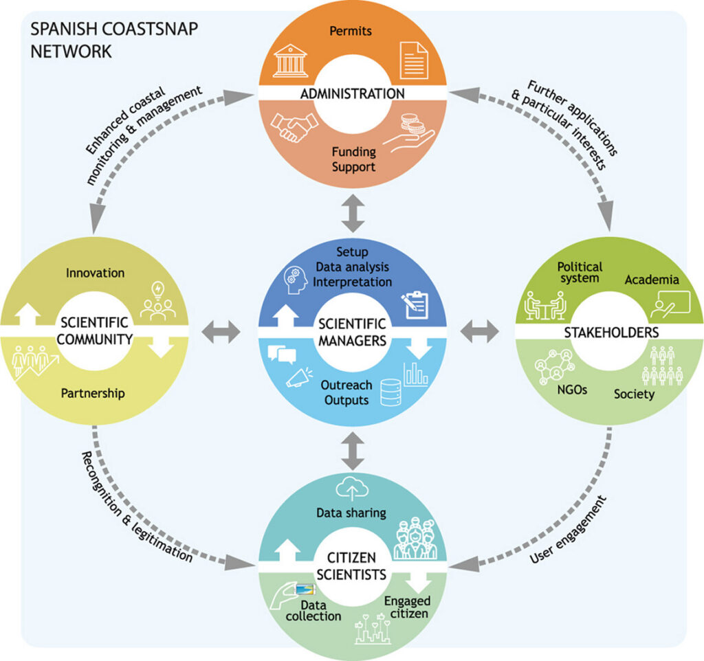
Figure: 1.- The CoastSnap approach: empowering community science to generate high-precision coastal data for research and management (Source: Soriano-González et al., 2024)
AI assistant in the loop: overcoming the shoreline-processing bottleneck
While growing citizen engagement and the continuous expansion of the CoastSnap network in the Balearic Islands generate an unprecedented number of photographs available for analysis, processing them has become a major operational bottleneck. Traditional manual shoreline delineation by experts requires hours of meticulous work, whereas traditional automated computer filters frequently fail when confronted with shifting light, complex hydrodynamic features, sun glint, wet sand or beach debris and wracks, scenarios where the maximum visual contrast may not match the true land-water boundary.
To overcome these limitations, SOCIB researchers jointly with the University of the Balearic Islands, developed the socib-shoreline-extraction module, an open-source deep learning module for automatic shoreline extraction in coastal images. Powered by a DeepLabV3 neural network architecture and acting like a trained human eye, the AI evaluates spatial context rather than strict color thresholds, enabling it to pinpoint the land-water interface in just seconds. The lightweight tool processes images directly without requiring complex spatial setups or heavy computing infrastructure.
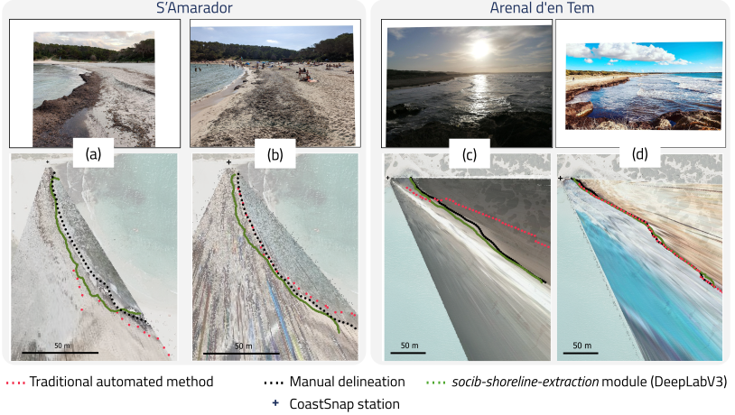
Figure 2.- Comparison of shoreline extraction performance at Balearic Islands CoastSnap stations. The AI model reliably detects the shoreline even under challenging environmental conditions such as sun glint, shadows, and beach wrack (a, c), while aligning with traditional methods in simpler conditions (b, d). Figure adapted from Oliver-Sansó et al., 2026.
Ready-to-Use Coastal Data Products for Managers
Beyond providing an open-source software tool for technical observation networks, we deliver ready-to-use data products directly tailored for coastal planners, engineers, and decision-makers to help them monitor beach dynamics and evolution. The framework generates georeferenced shoreline datasets, delivered as standardized, interoperable multipoint shapefiles, that record the precise location of the dynamic waterline at the moment of image capture. Rigorous validation against manually digitised shorelines demonstrates that the AI can extract shoreline positions with metre-level accuracy, achieving Mean Absolute Distance (MAD) values ranging from 2.6 m (Arenal d'en Tem) to 3.4 m (S'Amarador) in real-world terrain coordinates, approaching the uncertainty of manual expert digitisation while enabling rapid processing of thousands of images.
Because the shoreline position serves as a fundamental proxy for coastal change, having access to continuous, high-frequency datasets is a game-changer for long-term coastal management. As a dynamic boundary shaped by tides, wave energy, and sea-level variability, these multi-year shoreline time series allow managers to move beyond isolated snapshots and reliably track seasonal beach variability, identify erosion patterns, assess post-storm beach recovery, and evaluate long-term shoreline trends.
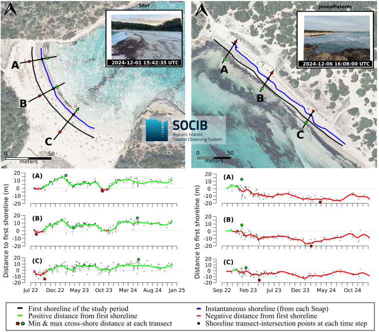
Figure 3.-: Multi-year coastal monitoring at S’Amarador and Arenal d’en Tem beaches using CoastSnap-derived data. Top panels illustrate the transformation of crowdsourced citizen photographs into georeferenced shorelines. Bottom plots display shoreline dynamics over years at three particular beach transects, capturing seasonal fluctuations and beach response to changing environmental conditions. The background used for the location maps is an orthophoto from PNOA (national plan for aerial orthophotography in Spain) sources (CC-BY 4.0, https://www.scne.es/). Figure adapted from Sánchez-García et al., 2025.
Open Data and services for European Coastal Intelligence
This development demonstrates that citizen science and artificial intelligence can contribute to generating research-grade data capable of directly supporting coastal management. By offering dual strategic value, our framework caters to distinct end-user profiles: it provides an open-source suite for technical observation networks, while supplying interoperable, ready-to-use data products for researchers, planners and decision-makers who require direct actionable metrics. This dual approach facilitates the transition toward autonomous, accurate, and accessible coastal monitoring.
All tools and datasets are freely available under a Creative Commons Attribution 4.0 International (CC BY 4.0) license.
- Learn more about CoastSnap: [Link to Web Page / Harley et al., 2019]
- The Spanish CoastSnap Network: [González-Villanueva et al., 2023 / Soriano-González et al., 2024]
- Explore the AI Tool: [Link to Application / Oliver-Sansó et al., 2026]
- Access the Datasets: [Link to Training Dataset / FOCCUS Shoreline Data Product]
- Further Inquiries: Contact the team at mobims@socib.es.
This work is a joint effort between the European Union funded projects FOCCUS (Grant Agreement No. 101133911) and iMagine (Grant Agreement No. 101058625). Views and opinions expressed are, however, those of the author(s) only and do not necessarily reflect those of the European Union or the European Health and Digital Executive Agency (HaDEA). Neither the European Union nor the granting authority can be held responsible for them.